SECTOR 29, POCKET B 2
Sector-29 Pocket-B2 Map Overview: A Comprehensive Guide to Residential, Commercial, and Community Planning
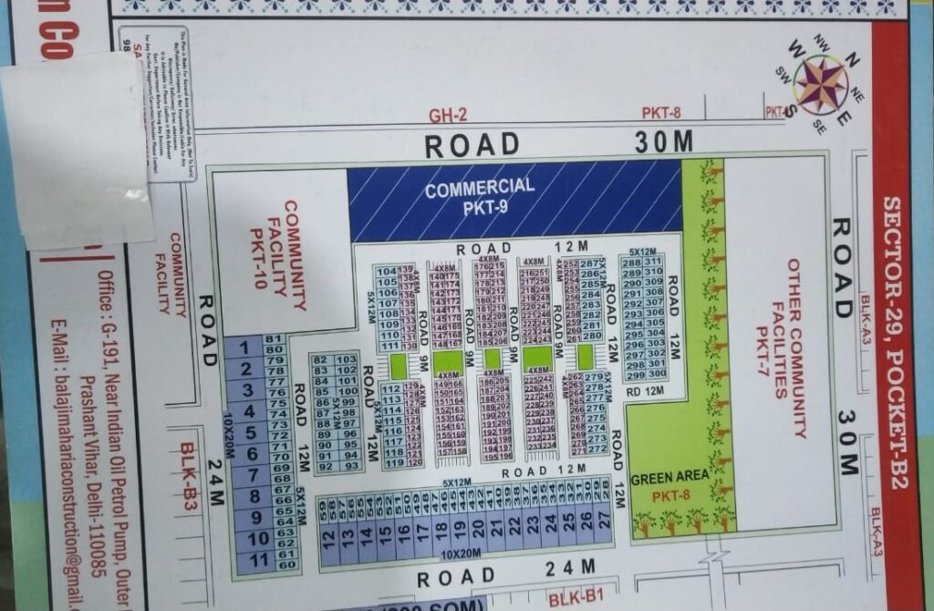
The map provided showcases a detailed layout of Sector-29, Pocket-B2, a meticulously planned area designed for balanced residential, commercial, and community usage. Located in Delhi, as indicated by the address at the bottom, this sector is part of a broader urban planning initiative that seeks to organize living spaces efficiently while ensuring accessibility to essential facilities.
The layout is bounded by multiple roads with various widths (30M, 24M, and 12M), enabling smooth vehicular movement and easy access to every part of the pocket. The north and west sides are bordered by 30-meter-wide roads, ensuring direct connectivity with adjacent pockets like PKT-7, PKT-8, and GH-2. The southern boundary is marked by a 24-meter-wide road, linking it to BLK-B3, while the eastern side connects to BLK-B1 and BLK-A3 via internal roads.
Residential Planning:
The heart of Pocket-B2 is mainly occupied by organized residential plots of varying sizes. Each plot is clearly numbered, with dimensions like 5x12M, 4x8M, and 10x20M, indicating a mix of small to medium-sized plots suitable for different types of homes, ranging from single-floor houses to multi-storey buildings. The plot numbers are arranged in neat rows with adjacent internal roads measuring 9M and 12M, ensuring good access and ventilation.
The residential areas are systematically arranged around green spaces and parks (marked in green), ensuring that each cluster of houses is within walking distance of a recreational space. This planning promotes not just convenience but also quality of life, especially for children and the elderly.
Commercial & Community Facilities:
To the west of the residential blocks, a wide commercial zone (PKT-9) is designated, colored in dark blue. This area is intended to house shops, small businesses, and possibly office spaces. Having commercial establishments within walking distance makes this pocket self-sufficient, reducing the need for residents to travel far for daily needs.
The community facilities are located at two strategic corners: PKT-10 in the southwest and another unnamed facility in the southeast. These are likely to include community halls, health centers, or schools — essential institutions that bind the community together. There is also a large plot marked as Other Community Facilities PKT-7 on the northern side, with a beautifully landscaped green area beside it, providing additional open space for large-scale community activities or events.
Road Network:
The internal road network is highly organized. Major internal roads are 12M wide, while secondary lanes measure 9M, ensuring smooth traffic flow without congestion. This design facilitates easy navigation for residents, visitors, and emergency services alike.
Utility and Orientation:
The map includes a compass rose for easy orientation, indicating the cardinal directions (North, South, East, and West). This helps understand sunlight direction, wind flow, and the placement of entrances or gardens for optimal design.
Furthermore, the presence of blocks BLK-A3, BLK-B1, and BLK-B3 around the map suggests future expansion or integration with adjacent developments, making this area a part of a larger, well-planned township.
Conclusion:
Sector-29 Pocket-B2 stands as a model for balanced urban planning, integrating residential comfort, commercial utility, and community infrastructure. Its well-defined layout with adequate road width, dedicated green areas, and proximity to community services creates an ideal environment for living, working, and thriving. Whether you’re a homebuyer, investor, or city planner, this map provides a comprehensive view of a thoughtfully designed urban pocket, ready to support modern lifestyles with accessibility, greenery, and organized infrastructure.
Sector-29, Pocket-B2 Map: A Well-Planned Residential and Community Development
The map of Sector-29, Pocket-B2 presents a thoughtfully planned urban layout, combining residential, commercial, and community spaces in a balanced manner. The area is well-connected through wide roads measuring 30 meters, 24 meters, and 12 meters, ensuring smooth traffic flow and accessibility. Residential plots come in various sizes like 5x12M, 4x8M, and 10x20M, catering to families of different needs. A designated commercial area labeled PKT-9 lies on the western side, offering space for shops and small businesses. Community facilities are strategically located in areas such as PKT-10, along with parks and green zones that enhance the overall livability and environment. The map also includes properly numbered plots, internal roads, and open spaces that reflect organized planning. With a focus on modern living, convenience, and community well-being, this layout stands as an excellent example of urban development designed for comfort, accessibility, and a high quality of life.
Sector-29 Pocket-B2: A Smart Blend of Comfort and Connectivity
Sector-29, Pocket-B2 offers a smartly designed urban space with a perfect mix of residential, commercial, and community zones. Wide roads (30M, 24M, and 12M) ensure smooth traffic and easy access throughout the area. Residential plots of various sizes are arranged in an organized manner, surrounded by green parks and open spaces. A dedicated commercial block (PKT-9) and community facilities (PKT-10) add to the convenience of daily life. The layout supports modern living with ample space, greenery, and accessibility. This pocket reflects efficient urban planning aimed at creating a peaceful, connected, and self-sufficient neighborhood.
